

FlightX - Airport Finder & Flight Plan Calculator

Description de FlightX - Airport Finder & Flight Plan Calculator
FlightX is a flight planning tool with an extensive worldwide airfield / airport listing.
It's an ideal application for VFR Pilots to plan a successful trip and cross reference other flight planning calculations.
Create Flight Plans
Find airports and airfields by code, description, or part thereof
Enables the user to create a flight plan
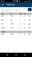
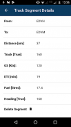
Calculate flight distance, flight times and track information for each flight segment and totals for a multi-stop flight plan
Provide information on airfields such as elevation, latitude, longitude
Calculate fuel burn based on burn rate specified
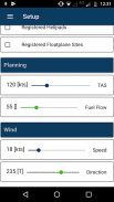
Heading information taking into account specified wind information
Calculating wind correction
The app will adjust existing flight plan calculation if any factor affecting these is adjusted
Find airports, airfields and other information
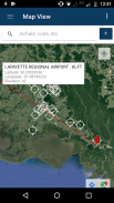
The app can switch between a map view, satellite view, or hybrid view to display flight information.
Flight plan information can be created visually on a map (click the info window), or via the automatic airport / airfield finder lookup. Simply start typing and the app will provide the best match to your search.
Additionally the app can search for closed airfield, registered heliports, seaplane port.
Particularly useful is the feature where the app can find all airfields / airports within a geographical region. Simply zoom in or out on the map, and select Find All Airfields on Map.
Note: that for the Australian region the app also can find VFR waypoints as registered in the EnRouteSupplement.
The app comes with a 30-day trial period, after which time an annual subscription can be purchased through the Google Play Store.
Developed by pilots for pilots.
FlightX est un outil de planification de vol avec une liste détaillée d'aéroports et d'aéroports dans le monde.
Il s'agit d'une application idéale pour que les pilotes VFR puissent planifier un voyage avec succès et croiser d'autres calculs de planification de vol.
Créer des plans de vol
Rechercher des aéroports et des aérodromes par code, description ou partie de celui-ci
Permet à l'utilisateur de créer un plan de vol
Calculez la distance de vol, les temps de vol et les informations de suivi pour chaque segment de vol et les totaux pour un plan de vol à escales multiples
Fournir des informations sur les aérodromes tels que l'élévation, la latitude, la longitude
Calculez la consommation de carburant en fonction du taux de combustion spécifié
Information de cap tenant compte des informations de vent spécifiées
Calcul de la correction du vent
L'application ajustera le calcul du plan de vol existant si un facteur les affectant est ajusté
Rechercher des aéroports, des aérodromes et d'autres informations
L'application peut basculer entre une vue de carte, une vue de satellite ou une vue hybride pour afficher des informations de vol.
Les informations de plan de vol peuvent être créées visuellement sur une carte (cliquez sur la fenêtre d’informations) ou via la recherche automatique d’aéroport / aérodrome. Il suffit de commencer à taper et l'application fournira la meilleure correspondance à votre recherche.
En outre, l'application peut rechercher un aérodrome fermé, des héliports enregistrés, un port d'hydravion.
La fonctionnalité permettant à l’application de rechercher tous les aérodromes / aéroports d’une région géographique est particulièrement utile. Il vous suffit de zoomer sur la carte ou de la réduire, puis sélectionnez Rechercher tous les aérodromes sur la carte .
Remarque: , pour la région australienne, l'application peut également trouver des points de passage VFR enregistrés dans le EnRouteSupplement.
L'application est livrée avec une période d'essai de 30 jours, après quoi un abonnement annuel peut être acheté via le Google Play Store.
Développé par des pilotes pour des pilotes.


